
AirHUD
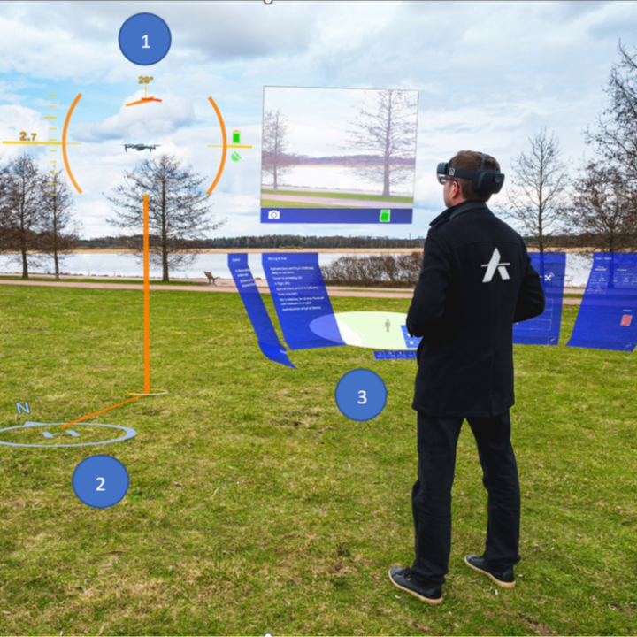
The first real heads-up display for professional drone pilots, showing the drone in a 3D 360° space at all times to boost situational awareness and flight safety.
Product dossier
Real-time views and maps
Enhanced awareness of the flight area
- At-a-glance data:
The interface surfaces drone status and location, a real-time map, waypoints, airspaces and no-flight zones.
- Circular map:
The World Map shows where the drone, pilot and home position are located.
- Big map:
Gives a fuller view of the flying area, showing surrounding buildings and their heights as 3D elements.
- Mark and plan:
Mark specific points, upload waypoint missions, and zoom in and out for a more detailed view.
Frequently asked questions
What challenges does AirHUD solve for drone operations?⌄
Drone operations can have several problems, such as:
1: Drone cannot be seen - too far away, is behind an obstacle, low-light conditions.
2: Poor situational awareness.
3: Legal requirement of a spotter.
AirHUD changes this and tackles these problems. Key benefits include:
1: Enhanced situational awareness on a totally new level, as the pilot sees it all and never loses the drone.
2: Fly the drone behind obstacles and still see its location and relationship to surroundings intuitively.
3: Height indicators are shown to allow for safe flights.
4: Fly with confidence at night or during operations which exceed visual line of site, as the drone is always pinpointed in the air.
5: Superimpose the display you would normally see on your controller over the real world, allowing you to see it and your aircraft simultaneously.
6: Spotter person can be relieved to more productive duties.
7: Helps keep the drone within visual line of sight, even when it is behind obstacles or obstructed.
8: Fly confidently in low visibility conditions.
How can AirHud and augmented reality benefit enterprise drone operations.⌄
Augmented Reality offers a range of benefits for drone industry applications.
Search and Rescue: Augmented reality can significantly enhance the capabilities of search and rescue drone operations, contributing to faster response times, more accurate decision-making, and increased overall efficiency - potentially saving lives. Overlay real-time information, such as maps, thermal imaging, hazards and vital statistics to enhance situational awareness and provide navigational assistance.
Security/Public Safety: Augmented reality can significantly enhance security and public safety operations to develop more effective security measures, faster response times, and increased overall safety, and protection. Overlay real-time information, such as maps, floor plans, camera feeds, and sensor data, onto the security personnel's field of view to better understand the environment and potential threats, and for more effective reconnaissance missions. AR overlays can also provide visual cues, highlight targets, and display relevant information, enabling security personnel to swiftly locate and track potential threats and individuals/objects of interest.
Mining & AEC: Augmented reality and drones in the mining and AEC industries offers multiple benefits. The ability to display augmented reality real-time data in hazardous, dark conditions with low ceilings and obstacles is very useful in mining environments.
Miners can see where their drone is, from around corners, understand the telemetry and help them to identify any potential risks before putting themselves in potential danger, and helps visualise digging areas to identify the next areas to explore.
In AEC, augmented realty can guide construction workers by overlaying digital instructions, measurements, and annotations directly onto the construction site.
Maintenance & Inspection: Maintenance workers can use augmented reality glasses with their drone to quickly locate damaged equipment or infrastructure. It helps increase safety in difficult-to-navigate locations and helps the pilot see the distance between the drone and obstacles, such as the distance between the aircraft and a turbine blade during windfarm inspection.
How do I install AirHUD on the DJI Smart Controller?⌄
To install AirHUD on the DJI Smart Controller, follow these steps:
1: Open Lightning Browser web browser
2: Visit app.airhud.io
3: Click the download link for latest DJI Android application
4: After file download is ready, open File Manager
5: Navigate to Downloads and select the .apk you just downloaded
6: Package Installer will ask you to install the application, click Install and AirHUD is now on your device ready to be used.
How do I install AirHUD on the Microsoft HoloLens 2?⌄
On the HoloLens 2, you need to make sure you have enabled unregistered software installs (as AirHUD is not yet inside Microsoft Store).
So, Settings > Update & Security > For developers.
There, enable: Use developer features, Device discovery, and Device portal.
You might also want to disable microphone from Settings > Privacy. This way the mic won’t pick up weird things all the time.
Steps while wearing HoloLens 2:
1: Download the apps from app.airhud.io
2: Click the application download link for HoloLens 2 application.
3: Plug the HoloLens into your PC if you downloaded the application.
4: Move the file to HoloLens Downloads folder. If you used HoloLens browser to download, then just go to File Explorer from main menu, All apps, and find the downloads (top left corner, switch from most recent to all files view…), and tap on the AirHUD installer.
5: You are asked for the PIN code or other security confirmation here.
The same steps go for installing for Smart Controller, of course. The Smart Controller will ask for the licence email and licence key that is provided earlier on first AirHUD startup.
6: Start the AirHUD on controller, accept EULA, insert licence information, confirm that connection to drone is okay (if it is powered on already).
7: Turn on the AirHUD in HoloLens, and you are ready to go.
Please note that if you have an old version of AirHUD in HoloLens, you may experience some difficulties while installing the new version. Therefore, when you want to install a new version, first you must uninstall the old version.
Is a licence required to use AirHUD?⌄
Yes, a licence is required to use AirHUD.
For fully-functioning AirHUD, the user must have acquired a valid licence and entered the licence information to the controller application.
The licence information is requested on the AirHUD controller application to get started. Enter the email address that you used for registering AirHUD in the Username field, then enter the key in the License Key field.
Ensure that the user credentials (username/licence key) are correct, otherwise AirHud will not be able to validate your licence.
What DJI drone controllers are compatible with AirHUD?⌄
A DJI Smart Controller is required to use AirHUD with compatible DJI drones.
Which are the best AR glasses to use with AirHUD?⌄
AirHUD runs on the following AR glasses:
Microsoft HoloLens 2
Trimble XR10
Meta Quest Pro
Which DJI drones does AirHUD support?⌄
The following DJI drones can support AirHUD:
M300 RTK & M350 RTK
Mavic 3 Enterprise Series
M30 Series
Mini 3 Pro
Mavic 2 Enterprise Advanced, RTK module also supported
Mavic 2 Enterprise
Mavic 2 Pro
Phantom 4 Pro V2
Mavic Air 2
Mavic Air 2s
Mini 2
Can I fly BVLOS with AirHUD?⌄
Yes you can, but AirHUD does not yet have the certification from competent authorities (FAA, CAA or EASA for example) to fly commercial BVLOS flights without a spotter. Many AirHUD users have the certification to fly BVLOS and have found that AirHUD is a good tool for that.
Common questions
- Which DJI drones does AirHUD support?
- Can I fly BVLOS with AirHUD?
- Is a licence required to use AirHUD?
- What DJI drone controllers are compatible with AirHUD?
- What challenges does AirHUD solve for drone operations?
- How do I install AirHUD on the DJI Smart Controller?